Idealized simulation of mesoscale energy propagation and dissipation at a western boundary.
In this published work, we investigate oceanic mesoscale energy dissipation at western boundaries.
I am interested in understanding how the mesoscale energy is dissipated given that mesoscale eddies are ubiquitous in the ocean and are nonlinear in mid and mid-high latitudes.
Keypoints:
Bottom drag dominates viscous dissipation when eddies are nonlinear, and the open-ocean region dissipates most of the total kinetic energy.
Western boundary might be important for mesoscale dissipation only when energy generation is nearby since eddies are fully nonlinear in mid and mid-high latitudes.
We need to investigate other dissipation mechanisms in the presence of rough bottom topography.
Double gyre simulation of mesoscale energy dissipation.
Next, we use a double-gyre simulation to investigate more dissipation mechanisms, such as eddy killing by wind, eddy-mean interaction, and the effect of rough bottom topography.
Satellite and Global Datasets
Daily bottom eddy kinetic energy from GLORYS12, a global ocean reanalysis dataset.
In this work, I am interested in using satellite and Argo datasets to estimate how much global mesoscale energy is dissipated by bottom drag.
Keypoints:
The first time using satellite and Argo datasets to estimate near-seafloor EKE and drag dissipation rates.
Calculate EOF vertical structures from GLORYS12 dataset (Jean-Michel et al., 2021) to reconstruct near-seafloor EKE.
Global bottom drag dissipation is $O.19\ \mathrm{TW}$, which is too small to dissipate the $1\ \mathrm{TW}$ of wind input to geostrophic flow. This work is under preparation for a GRL publication, and stay tuned for the preprint.
Nearshore Research
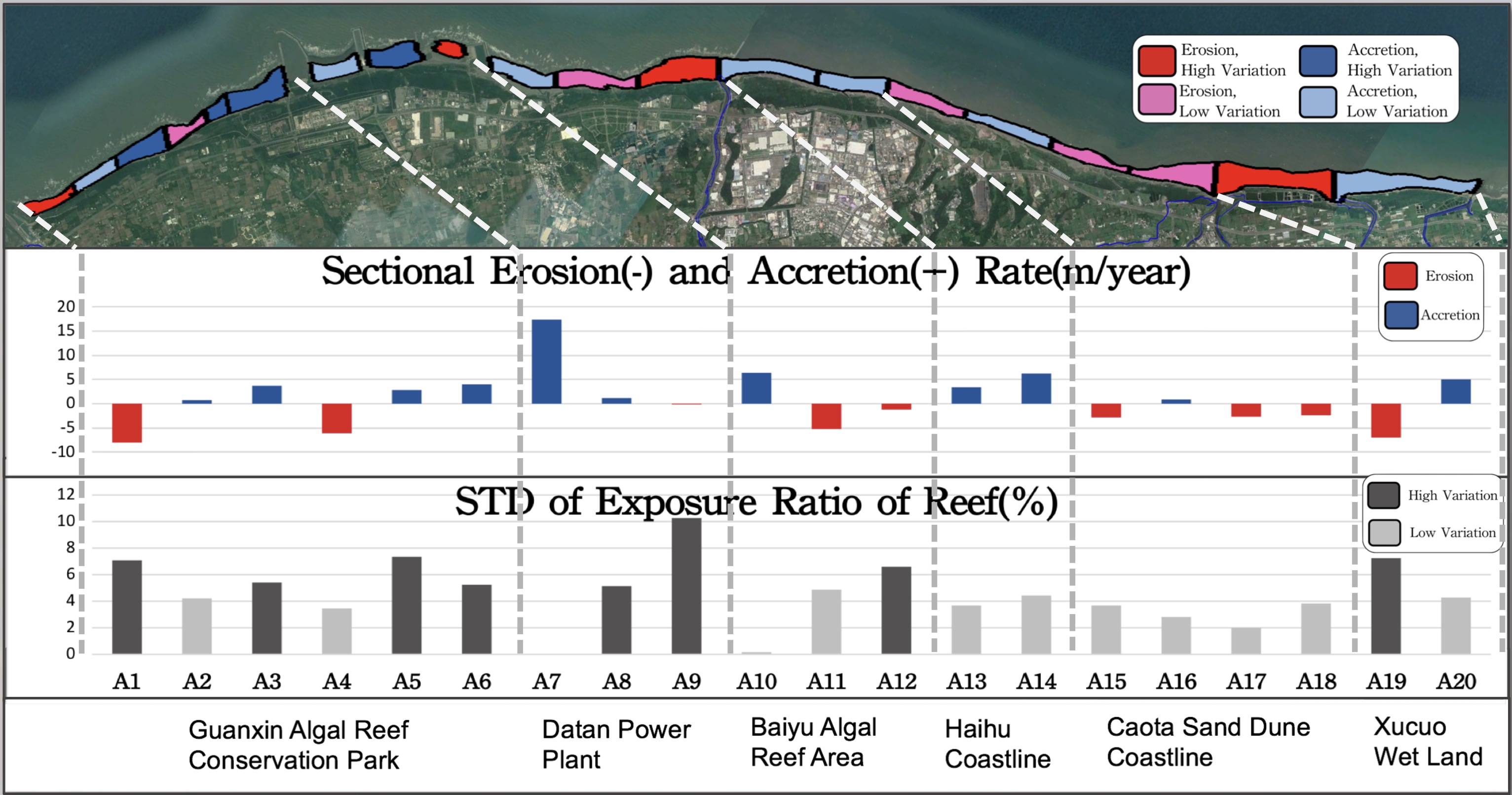
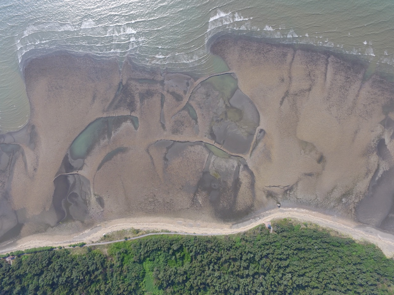
Erotion in Taoyuan coast and reef exposure. Source: AGU 2019 poster presentation
I started up a team of nearshore sand coverage monitoring in Taoyuan, Taiwan.
I was the Unmanned Airborne Technique team leader and performed field work, data processing, and analysis.
I developed an effective operating system for this research team which has successfully continued this project, in part due to the training practices I helped develop.
UAV LiDAR research
I contributed to the UAV LiDAR system development (Hunag et al., 2018).
This autonomous system can measure waves, tides, wave energy dissipation (published in 2020 ICCE conference proceedings 10.9753/icce.v36v.waves.34, video), and the roughness of the topography.
In addition to the nearshore physical dynamics research, I also participated in the archaeological landscape investigation in Xinwu, Taiwan, which uses airborne imaging techniques and hydrographic measurements to understand the fishing weir sites and their relationship with tidal dynamics.